Chunky Gal Mountain
📍Nantahala National Forest, North Carolina
If you’re looking to venture beyond the many public ruby and sapphire mines of Western North Carolina, Chunky Gal Mountain gives you a chance to try your own prospecting skills. It’s an 8 mile ridge in the Nantahala National Forest. There’s no flumes or paydirt buckets… just your prospecting skills.
GPS coordinates:
35.08928, -83.61994
Treat these as a rough starting point. It’s a general area to explore, not one specific point.
Land type:
National Forest
Digging fee:
None
What can you find?
Chunky Gal sits on an ultramafic bedrock called dunite. The corundum here will be found embedded in smaragdite, which is a green host rock that’s full of chrome. Looking at night with an ultraviolet night will make it far easier to see corundum, especially if pieces are partially covered in muck or mud.
Alongside the corudum, you may also come across almandine garnets, spinels, and rutile. By no means is this a complete list. This site has been prospected and enjoyed for many, many years.
When out here, you’ll be hiking and doing true backcountry prospecting. There isn’t one exact “pit” or cliff. Searching the creek gravels can also be productive for small gemstones that have made their way out of the smaragdite host rock. Make preparations to be in remote country with wildlife including bears.
Collecting notes:
At most National Forest sites, collecting is limited to personal, non-commercial use. Hand tools only, power tools are not permitted. This is true public land. Don’t leave open holes, pack out your trash, and a piece or two of litter if you find it. Treating these sites well is important for keeping them open in the future.
Location-specific note: There are some locations in Western North Carolina that are still closed in Summer of 2026 following extensive damage from Hurricane Helene. At the time of writing this, it appears that the Chunky Gal area is open and accessible. Follow Forest Service guidelines if this changes or if roadways shut down for construction/repair.
Seasonality:
This site is open year round, as long as the forest roads are passable. In North Carolina, March through November tend to be best for rockhounding.
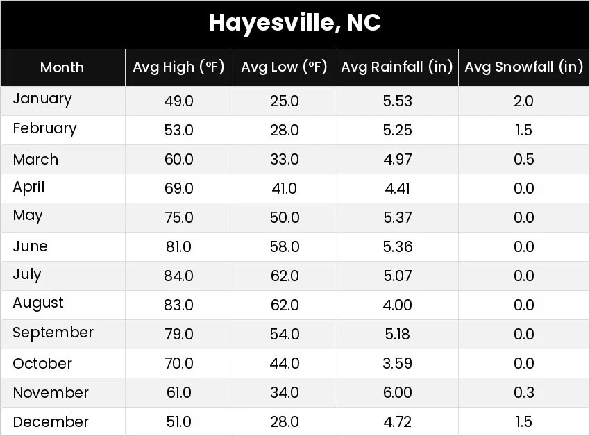
Weather by month (using the nearest town):
Road condition notes:
Road conditions vary drastically on National Forest roads.
Public bathrooms: No
Showers: No
RV hookups: No
Additional information:
Tusquitee Ranger District office: (828) 837-5152
sm.fs.tusquiteerd@usda.gov
This is an unvisited location and the information may be incomplete or have errors. If you have information to add about this site (or others), you can fill out the info form below. It is possible to contribute anonymously and takes 1-2 minutes on average.
Navigation